How to fetch the total Ozone Data from GOME
Francis
Massen
file: fetchgome.html
version 1.01 04 Mar 2003
|
How to fetch the total Ozone Data from GOME Francis
Massen
|
| Abstract | It is shown how to fetch the total ozone data of the location of meteoLCD from the GOME assimilated data files |
Comparing the Microtops II measurements with other available data sources is
important to detect either a constant offset between the instrument used at
meteoLCD and other institutions, or to make checks for an eventual increasing
mismatch . The paper
"A comparison of the total ozone measurements done with
the Microtops II sun photometer and the Uccle Brewer spectrophotometer"
does this for the last 6 years: the conclusion is that the meteoLCD data are
probably constantly too high, and that a multiplier of approx. 0.94 should be
applied to the readings to yield data equal to the Uccle Brewer measurements.
Uccle is located at about 150 km West from Diekirch ( Uccle longitude = 4°21'
East, Diekirch 6°10' East), what is enough to give a difference of 10 DU
magnitude, as suggested by the satellite data ( Uccle and Diekirch are approx.
neighbour cells in the data file)
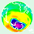
"The
Global Ozone Monitoring Experiment (GOME) was launched on the 21 April 1995 on
board the second European Remote Sensing Satellite (ERS-2); This instrument can
measure a range of atmospheric trace constituents, with the emphasis on global
ozone distributions. GOME is a
nadir-viewing spectrometer that measures the solar radiation scattered by the
atmosphere in the ultraviolet and visible spectral region (240 to 790 nm). The
sensor has a high spectral resolution of 0.2 to 0.4 nm sensed by four individual
linear detector arrays each with 1024 detector pixels. The field of view may be
varied in size from 320 km x 40 km to 960 km x 80 km. For further information
and the mission objectives see the sensor
information sheet."
(quoted from the Gome home page)
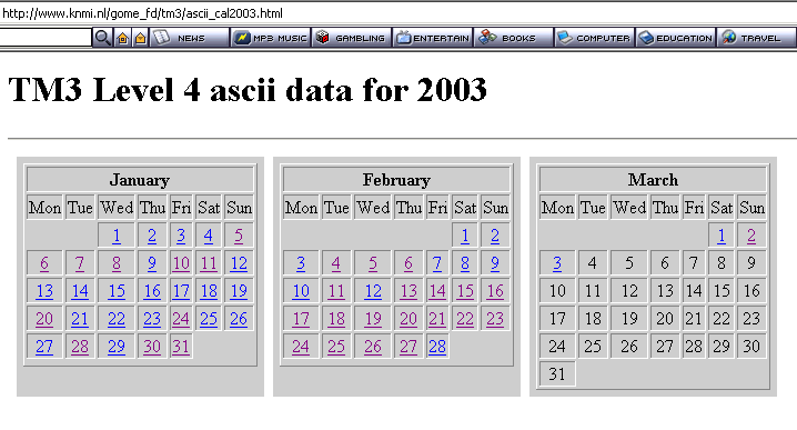
The Gome data files are freely available on the internet at (for instance) the Gome Fast Delivery Service page of the KNMI from the Netherlands. As Gome takes 3 full days to get a complete coverage of the globe (each swath width is 960 km; see figure1 of http://www.knmi.nl/gome_fd/tm3doc/tm3dam.html), a technique called data assimilation combines observed data with a numerical model (TM3-DAM) to "fill the gaps". These assimilated data files (called TM3 level 4) are available as Ascii data for 12:00 UTC of every day of the year (see the preceeding link for a more complete explanantion).
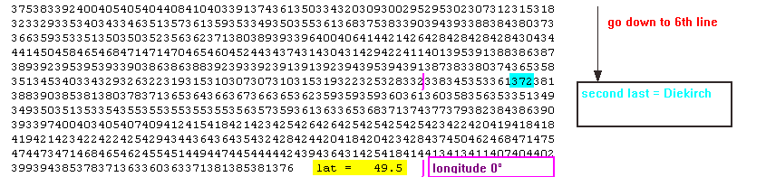
The following steps show how to find in the (impressive) daily data file the reading corresponding to the location of Diekirch ( latitude 49°52 North, longitude 6°10 East):
| 1. Go to the level 4 data page of the Gome Assimilated Ozone Fields page: http://www.knmi.nl/gome_fd/tm3/ascii_cal2003.html |
| 2. Click on the day of the month; Gome data always apply to 12:00 UTC ! |
 |
| 3. Find the data block corresponding to a latitude of 49.5 North (positive latitude): Diekirch is second last block at 6th line |
 |
The Gome reading of the current day may be found directly by following the link given at the bottom of the Live Weather page of meteoLCD